Indescribable

Indescribable

Guest post by Sandi Adams

Not a single day goes by that my attention is not caught by some amazingly beautiful sight outside. It appears that the older I get the more deeply I cherish what is around me. When hiking, I like to touch the bark on the trees, the moss on the rocks, dip my fingers into the creeks. I love to lie on the ground and listen to the earths heart beat and look at the tree branch silhouettes against the sky…. REALLY notice the little details. Every season offers treasures to be enjoyed if we just take the time to notice.

I read somewhere that the average person has 32,850 mornings, (assuming you live to be 90 which I am planning on) That means I have approximately 14,550 or so more to go. I don’t want to waste a single day.


Recently my son shared a DVD by Louis Giglio called“Indescribable” (You can watch the series on you tube in Five Parts)
It was a message inspired by Chris Tomlin’s song with the same title. I marveled at what a tiny speck we are in the universe and how everything we can see, smell, touch and taste is so intricately designed. It inspired me to look even deeper at my surroundings and consider our place in this world. Click here for some gorgeous images and video with the ChrisTomlin song.
The heavens declare the glory of God; 
the skies proclaim the work of his hands psalm 19:1

How I want to be when I grow up…

This is a seriously AWESOME post by Dame Sandi Adams!!

Inspiring Aging or How I Want to Be When I Grow Up…

I’ve thought a lot about getting older lately… Probably because I am older. This birthday, I finally conceded to being middle aged…, considering 106 to be a respectable run. Sometimes I look in the mirror and am surprised. In my head, I don’t feel different and my body is still strong. ( though a few chinks in the armor are beginning..)
That is why I adore reading about people, who challenge themselves and are still moving, dancing, hiking, playing and living out dreams.

Last week I came across a blog post on Hiker to Hiker, that reallycarolina mt club made me smile. It was titled “Taking Care of the Elderly on the AT” The Carolina Mountain Club had planned a 9 mile hike led by an 81 year old. They all are over 50, as they point out, some way over 50. (These are my people)
Even thought it was hot, (we are southerners and it is hot here in the summer….) and the weather man kept telling them to “be careful and check on the elderly,” they still kept it moving and had a splendid day on the Appalachian Trail.

I’ve also been following Cimarron, an 88 year old man who has been THRU HIKINGthe Appalachian Trail since February and has completed 914.5 miles as of today.

cimarrontj11863_060811_183637_617926tj11863_061011_164724_618339
His quote before starting says it all, “If you never try to do it. You will never know you could do it.” You can read his trail journal HERE

This week Diana Nyed attempted to swim from Cuba to Key West, Florida at the age of 61. Moments before slipping into the water, Ms. Nyad, clad in a black swimsuit and a blue swim cap, played reveille on a bugle. “I’m almost 62 years old,” she declared. “I’m standing here at the prime of my life; I think this is the prime, when one reaches this age. You still have a body that’s strong, but now you have a better mind.”

While her journey was cut short, she still managed to swim for 29 hours, t1larg_diana_swimming_day1suffering through an asthma attack, shoulder pain, in cold. shark and jellyfish infested waters and finally abandoning her quest after becoming violently ill. Her comments following the experience were inspiring. She said that her goal had been to demonstrate to people in their 60s that “life is not over” and that the age of “60 is the new 40.” “I wasn’t the best swimmer I could be — the asthma and the shoulder made sure of that,” she said. “I was my most courageous self.”

Life goes by so quickly and, at my age, you really feel the passage of time,” she said. “People my age must try to live vital, energetic lives. We’re still young. We’re not our mothers’ generation at 60.” For people over 60, she said, the goal should be “to live a life with no regrets and no worries about what you are going to do with your time. Fill it with passion. Be your best self.”
I think these are words that are worth living by no matter your age. So if you are sitting around on your hiney feeling sorry for yourself, put one foot in front of the other and you never know where you might end up.
We should all try to be our most courageous selves…

Trail Report-Pine Log Creek Trail

Trail report from Dame Sandi Adams…..

Pine Log Creek Trail….has it ALL!

Total distance: 4.6 miles
Parking lot Lead Trail: .46
West Loop : 2.12
East Loop: 1.54
Quarry Trail .03

After a friend at work told me about this trail, I put it on my short list for spontaneous hiking.(Also while searching for information about this trail, I read of a stray nude hiker that appears on it but this did not in any way influence my decision….) Friday morning started cool compared to the inferno heat we have been having so David and I packed it up and headed off to try it out.

Pine Log Creek Trail is located in Bartow County only 25 miles from our doorstep. We arrived early to an empty parking area, strapped on the pack and after viewing the faded out map posted, took off to the sounds of birds chattering and a neighboring rooster going crazy. Shortly after crossing a dry creek bed we came to a cool running bend in the creek with a beautifully built wooden bridge crossing. There are actually seven rustic footbridges over Pine Log Creek throughout the well maintained 5 mile hike. The trail includes two loops east and west and a short side trail to an old CCC quarry pond.
We opted to take the east loop first which took us over the creek and through a series of switchbacks to peaks of views of Pine Log Mountain. (Winter will be spectacular!) This trail overlooks a pastoral valley that was once home to the Cherokee village of Pine Log before the native people’s removal west on the Trail of Tears in the 1830s. There are numerous large rock croppings and boulders. The black eyed susans, several varieties of fern,( some HUGE), many giant very old trees along with the winding creek made this a very diverse beautiful trail. We saw traces of the stormy Spring in the form of someones chicken house roof scattered throughout the forest and brush.
The jewel of the trip was located a short distance off the trail in the form of an old quarry pond. David quickly identified several large mouth bass, brim and a stray catfish in the clear water vowing to bring a fishing pole the next trip. (NOTE: There is a large sign that prohibits fishing and overnight camping at the trail head) This was a peaceful, beautiful treat and great spot for a lunch or a quick swim.
After exploring the quarry we picked the trail back up and came to the west loop junction continuing over the creek and up the ridge for more views. We took a short stop to hang my hammock for David to tryout and discovered a little box turtle who watching our efforts. One thing to be aware of with this trail is someone has removed the trail loop signs. The posts are there but no signs. We found ourselves taking the east loop again before catching our mistake.
We ended our hike by cooling our feet and wading in the creek under the entry bridge. We both commented that it reminded us of childhood locations where we were free to play and explore. The only “excitement” of the trip came while we were drying off and observed a snake drop off the bank and swim right into the area we had been in. Of course I identified it as a copperhead or water moccasin but really think it was a red rat snake…
This trail is most definitely a jewel and will be on our list of backyard favorites.

http://www.youtube.com/watch?feature=player_embedded&v=4YE_ETyaTCM

Difficulty: Moderate-Some parts are listed as strenuous but not really
Directions
from I-575 in Canton: Take Riverstone Pkwy exit 20, head West for about .5 mi. Take right onto Reinhardt College Pkwy and continue until it dead ends into Hwy 140. Take right onto Hwy 140 W (still also Reinhardt College Pkwy) and go approximately 12 miles. Trail head will be on your right.
From I-75 in Cartersville: Take exit 293 and head North on Hwy 411 for about 7.5 mi. Take a right onto Hwy 140 East and go about 3.2 mi, trail head will be on your left.

Backpacking with Beiber

Backpacking with Beiber…..another wonderful post from Dame Sandi Adams


Backpacking was on Tanner’s summer bucket list, so we planned an overnight midweek trip. I chose the Cohutta Wilderness because it is my absolute favorite Georgia spot to backpack.
Meals were planned, maps consulted, the packs were loaded and off we went. The morning was sunny and warm as the Yaris took the rutted labyrinth of forest service roads like a champ and after what seemed like a hundred miles, we came to the Hickory Creek trailparking area. Not one soul to be seen… I checked the board for bear warning and nothing was posted which was a bit of a relief.
Perfect DayHickory Creek Trail HeadTanner and I adjusted our packs, locked the car and took off down the trail. The first part of the Hickory Creek Trail was rocky and weathered with evidence of the spring storms and all downhill as it wound its way to the creek. We hear the water before we can see it and soon get glimpses of the creek before our first crossing. Crystal clear, with plenty of water, it keeps us company as we continue down the trail. Soon we hit the intersection of theConasauga River Trail and Hickory Creek Trail where we turn right and begin looking for the perfect campsite.
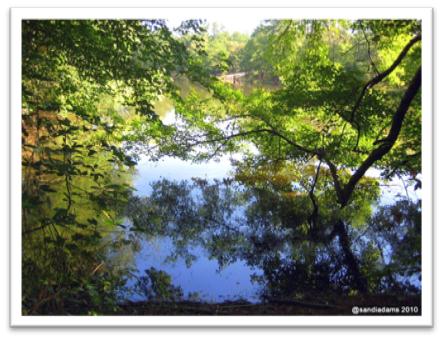
Before long we come to the perfect balance of trees for my hammock and a niceIMG_2147 flat spot for the tent. The entire length of the site is situated directly on the Conasauga with a combination of deep pools ,little falls, huge boulders and the constant melody of the river. A covering of hemlocks, a nice big fire pit and a makeshift bench make it the unanimous choice. We go about the business of setting up camp, unpacking, gathering wood and having lunch.

IMG_2123After a short rest, we leave our site and head down the trail to explore.. We pass ginormous boulders, falls and swimming holes, a huge beaver dam which has turned into what must be a diverse mass of frogs, toads and Lord knows what else and come to the opening and intersection known as Bray field. (This used to be an old homestead but is now mainly used by backpackers.) We take off our shoes and wade across the Conasuaga River before I realize, we really don’t want to hike the entire Hickory Creek Trail, so we cross again and travel a bit down Tearbritches Trail, rockhopping the creek and wander along this beautiful easy section of the trail.
As the day turned into late afternoon, we head back to camp and take a swim in the cool clear river . We both enjoy some quiet time, then get to the business of preparing for the evening. We break up our wood, filter our water and settle down to cook dinner. Tanner is a great student of the outdoors, watching my every move and made my day when he tells me, “Mom, I can’t believe you know how to do all this stuff!!” After a satisfying, (although bland) meal of beef stroganoff and pudding, it starts to cool off and we get down to businessTanner and MomAwesome fire!and startthe fire. For years, I have watched my best friend, Leslie,THE FIREMASTER, start epic blazes. I have always been content to gather kindling and drag logs to the pile but she was not on this trip! Apparently, I was able to channel her talent and build one big honking fire!
We roasted a small bag of marshmallows, talked and stared into the fire (aka Hikers TV), until it got pretty late. The moon was new, so the night was DARK.
We made our way to our shelter, Tanner on the ground and me hanging in my hammocknearby and dozed off to the sound of the river. I woke around 7:00, rolled out of my warm bag and started another little fire. (Leslie, are you so proud?!) Sitting and drinking coffee and enjoying the beautiful cool morning, I counted my many blessings, one of which was laying in the tent next to me.
Tanner slept a little longer and finally crawled out, ate his bacon, cream cheese bagel and we reluctantly started to break camp.
IMG_2119Morning firePacked up to head homeDay Two

We climbed out of Hickory Creek around noon as the day warmed,IMG_2222taking our time while I told Tanner funny stories about David and our many adventures in the woods, pre-kids. An occasional stop for water, a view and to admire a little red salamander made for an enjoyable although, hot hike out.
On a funny note, as we reached the trailhead, I noticed that theBACK side of the information board was COVERED with bear warnings and information underneath the engraved message:WELCOME TO BEAR COUNTRY……LOL THIS was the BACK side of the trail head sign....
We loaded up our gear and took the rutted forest service road back toward 411 and after what seemed like fifty miles bouncing from bump to bump, popped out in the middle of nowhere . After consulting the map, we found our way to 411. A quick stop at a convenience store for icees and beef jerky and made our way back to Woodstock and civilization.
This trip will always have a special place in my heart and I will cherish it’s memory. My son,natural backpacker Tanner, is an incredible young man. He has been through adversity and difficult times but has emerged strong and confident with a natural, loving, unshakeable faith in God. I am proud of him and grateful for the time spent.

Smoky Moutain Backpacking

This is a re-posting from favorite Dame, Sandi Adams. Check out her great blog at http://emptynestart.wordpress.com/

Smoky Mountain Backpacking Trip

This three day trip started with a bang, literally, as I was making the trip to Clarkesville to pickup Kellye to head to the Great Smoky Mountains for a three day backpacking trip with SHOE and Turtle. I had to make an emergency pit stop in the dark, under an interstate bridge pylon and sacrificed my favorite pink bandana…
When I get to Kellye’s I realize my camera is missing and we have to backtrack to the scene of “The Incident” where I find it laying next to my pink banadana…

Hopeful that this was not going to be a theme for this trip, we headed to the hills.
We met our hiking buddies, SHOE, (slowest hiker on Turtle, Sassafras, SHOE and the newly named Ratchet.....earth), and Turtle at the Smokemont campground dropped my car at the Mingus Creek Trailhead and headed to theThomas Divide Trailhead. Thomas Divide is named for William Holland Thomas (1805-1893,) who gained so much favor with the Cherokees that he became the only white man ever appointed Chief. This self-educated lawyer lived with the Indians, learned their language and ways, and defended their rights in Washington. He helped purchase much of the land known as the Qualla Boundary. He was a Confederate Colonel and the bravery of his Thomas Legion of Cherokee Indians and Highlanders is legendary. (Sorry for the history lesson, but I found this interesting)

IMG_2461The trail was moderate with some decent climbs and rewarded us with the diversity of flora and fauna that makes the Smokey Mountains unique. The rhododendrons were abundant and still in full bloom. Yellowish brown cobs of squawroot poked through the leaves. I couldn’t remember what they were called but found out that this is a favorite food of black bears. (We saw much evidence of bears but figured that four chattering women would be enough to scare any bear off!)
We took our time on this warm, sunny day, catching up and taking turns leading the hike. As elevation changed, so did our surroundings. The ghostly silhouettes of hemlocks ravaged by the woolly adelgid against the sky, numerous coves of hardwoods and always the forest floor was alive with fungi and wildflowers.
Arriving at Campsite #52, at Newton Bald, we found a solitary camper who had set his five manIMG_2506 tent up in the center of the fire ring area! Kellye scouted the area and found the perfect ridge top spot to spend the night. While we searched for the perfect hammock trees and Lesly and Melissa looked for a flat spot for their tents and we began the ritual of setting up our temporary home for the night.
Our first “excitement” of the trip occurred when Kellye wandered off to take care of some personal business and interrupted a bear! The bear grunted a warning to let her know he was there and they both took off in opposite directions. She quickly came back to home base, eyes wide and put us all on alert that we were not alone!! Needless to say, I did not wander far to take care of my personal business after that!
IMG_2531Dinner was cooked and we spent an inordinate amount of time coaxing flames out of a stubborn fire, night fell, the temperatures dropped into the upper fifties and we all retired to our sleeping quarters. I listened to a little bit of Pat Conroy’s latest and drifted off to sleep only to bejolted awake by the sound of what I was sure was a BEAR climbing the tree that my hammock was attached to!!! The commotion continued as everyone scrambled out of their tents asking Kellye if she was okay, so I rolled out and found her hammock had “ratcheted” DOWN the tree!! Fortunately, she was fine and we all went back to bed. (We think she might have a trail name, Ratchet!)
Day 2, we took our time with breakfast and breaking camp, enjoying the cool IMG_2497temperatures before beginning our hike. We continued on Thomas Divide heading to Deep Low Gap, again enjoying the diversity of the trail. Excitement came when Lesly and I spotted a small creek off the trail. She needed water and I dropped my pack and went off the trail to capture a photo of some red bee balm. Immediately what felt like needles on my legs caused me to scream, as the realization thatyellow jackets were swarming around us! Needless to say, we both moved quickly but not before I had at least 12reminders of why I never want to step in another yellow jacket nest. After retreating a safe distance we took a break where everyone contributed Benadryl cream, anti-itch and Neosporin to ease the sting. (Truth be told I wanted to cry, but satisfied that urge with talking with my trail mate.)
IMG_2585As we began our descent into the lush green forest, crisscrossing small streams, it occurs to me that we have been going down alooooong time and that we will bebacktracking up this haul tomorrow morning…….We reach our destination, the very slanted world of campsite #51. Being in the Gap, there is little breeze and the temperature and humidity have increased. Again, we repeat the camp setup ritual spreading out due to an absence of flat areas and spend the rest of the day, chatting, sharing stories, laughing, eating and daydreaming.
As night falls, I gratefully climb into my hammock and quickly fall asleep, only to be awakened around 3:00 am to thunder and rain. After assuring myself that my tarp was secure and all my belongings were underneath and dry, I slipped back to sleep until dawn. Our plan was to leave early, due to the number of miles and difficulty of the trail for the day, so I packed my hammock and gear and sat under the tarp drinking my coffee and eating a builders bar. (a nice perk of having a hammock means you can pack everything up underneath the tarp, leaving it for last) 
We all begin the slow tortuous climb in the rain to the intersection that will takeIMG_2610 us to theMingus Creek Trail and our car. Seriously, even though I have eaten most of my food, my pack feels just as heavy as when I started and it takes me a bit to find my trail rhythm.Unfortunately a couple more yellow jackets find my rhythm and get between my pack and back delivering more stings!! We space out a bit, each hiking our own hike and meet sweaty and tired at the top of the climb. A downhill stretch follows along the creek and takes us to 90 foot waterfall. It is still IMG_2628raining, so the photo op is cut short as we slip and slide across a narrow bridge crossing and continue down to the trail intersection, where thankfully the rain ends and the sun starts to stream through the trees. After consulting the trail map, we take off on the Mingus Creek Trail. The trail starts innocently enough, absolutely beautiful and follows and crosses the creek for some time. As the temperature and humidity increase, so doesThank the Lord we are at the top! the climb. Kellye and I hike together, stopping periodically to curse the trail and sip some water, even taking a break or two for a gu and bar break. As always, about the time, I think I can’t lift my leg another step, we reach the top and collapse for a well deserved break! This was a tough trail! Spotting the trail sign for Newfound Gap Road at 2.9 miles made us very happy!!
However, that happiness was short lived as we began the trek over a jarring, rocky, mossy, slick downhill!! BUT it was sooooo beautiful. If we had more time, I would have loved to linger at the many creek crossings and moss covered logs that called my name! But at that particular moment the lure, of my dry clothes and a burger at the NOC were a motivating factor! As we got closer to our destination the trail widened and we were able to walk side by side, recapping some of the highlights of the trip. The aching shoulders, legs and blistered feet were replaced by the pure joy of spending time outdoors and conquering YIPPEE!! I MADE IT!any difficulties that came our way.
As we burst into the parking area and into reality, I contemplate offering the nearby picnickers a $10.00 bill for a cold drink. NOTE: If you ever see dirty, sweaty, smelly people piling out of the woods with their life on their back, offer them a cold drink, they will never forget you!
The reward for this journey ends at theNantahalah Outdoor Center or the NOC. I have been hearing about the Flamethrower Burger and the HOMEMADE chips for the entire trip and satisfy this fantasy with my friends. A berry cobbler topped with ice cream is the icing on the cake. Sitting on the river with my feast and friends, I count my many blessings and dream of the next adventure…..
The best burger EVERIMG_2691Berry cobbler....Don't judge we just hauled our life on our backs for three days!!