Ever noticed that the forecast for the nearest town to a hike may be vastly different from the conditions up in the mountains? You can get the forecast for any location in the mountains or in the middle of no-where using the NOAA website. They have an interactive map that provides the “point forecast” for your hiking destination using a Google Map locator.
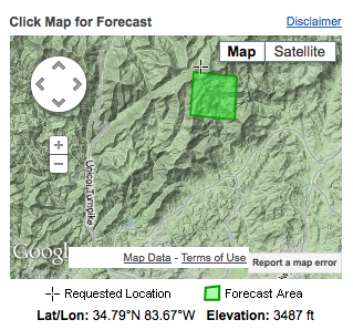
Here is an example for Tray Mountain:
Here is how I get this forecast:
1. Go to the main NOAA website![]() and the left box labeled “Local forecast by “city, St.” Enter in the nearest town to the hike.
and the left box labeled “Local forecast by “city, St.” Enter in the nearest town to the hike.
2. Scroll down to the middle of the page, and on the right side, locate a box with a google map labeled “Click Map for Forecast”. Move the map by dragging your mouse on the map and zooming in and out to locate where you will be hiking. Double click on the location to select the location of interest. It will then become highlighted by a green box. NOTE: I find it helpful to consult my National Geographic Trails Illustrated Map (#777 and #778 for our area) which shows detailed trail/town and road locations on a topo map so I can orient myself on the google map (which doesn’t always show trails but does have contours).
3. This will provide a forecast of the exact location of the hike. I take the forecast for the highest elevation I will be at for the day.
Here is more information if you have trouble or want to learn more.